
Archive Record
Images

Metadata
Object ID |
2009.1076.10 |
Title |
Preliminary Master Plan of West Chevy Chase and Vicinity |
Object Name |
Report |
Date |
1959 |
Creator |
Maryland National Capital Park and Planning Commission |
Description |
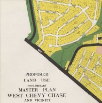
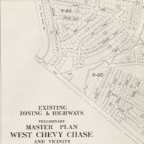
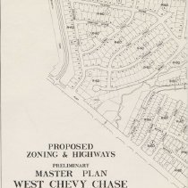
Preliminary Master Plan of West Chevy Chase and Vicinity Montgomery County, Maryland Published by the Maryland National Capital Park and Planning Commission circa 1959 Summary: "This Preliminary Master Plan for West Chevy Chase and Vicinity Proposes to extend the limit of the commercial center at Western and Wisconsin Avenues, to permit a limited amount of R-H, Multiple-Family, High-Rise Planned Residential development at the northwesterly boundary of the commercial area, and the acquisition of a large part of the Bergdoll tract and other properties for park purposes. The Plan also proposes to maintain, with the exception of the commercial center, the single-family development already existing in the study area and to reaffirm the R-10, Multiple-Family, High-Density Residential, zoning on the south side of Chevy Chase Drive which is a part of the Bethesda Zoning Plan. In addition to the above, a limited number of street and highway widenings, relocations and abandonments are proposed, all of which are explained in the following report." HISTORY: Contained within the study area is the Town of Somerset and the special taxing areas of the villages of Friendship Heights and the Hills, Drummond and a portion of Chevy Chase. These areas were created by the General Assembly in the period between 1912 and 1916 for the primary purpose of providing street development and maintenance at a time when such upkeep was poor or probably non existent. Immediately prior to World War II, the development in this section of the county was predominantly single family residential, there being but a small nucleus of commercial uses on both sides of Wisconsin Avenue at its intersection with Western Avenue. Some residential properties on the west side of Wisconsin Avenue north of the commercial development had been converted to tourist homes. The area bounded by Oliver Street, Kirkside Drive, Wisconsin and Western Avenues was vacant, as well as the land now occupied by the Government Employees Insurance Company office building and the Woodward and Lothrop department store. The Town of Somerset was developed only as far south as Essex Avenue, leaving a considerably larger Bergdoll tract which, at that time, extended from Dorset and Essex Avenues south to the corporate limits and from Wisconsin west to the northeast boundary of the industrial area at the intersection of the Georgetown Branch of the B & O Railroad and River Road. Park development in the study area was confined to the Bethesda Chevy Chase, Recreation Center at the end of Norwood Drive, one of the first in the county, having been acquired from the U.S. Department of Agriculture in 1937. West of the Center and extending from Fairfax Road southerly to River Road there existed a continuous stretch of undeveloped land, a large portion of which has now become the Little Falls Branch Park. The post war building boom not only brought extensive changes to the landscape of this area but to much of the territory within and surrounding the District of Columbia. Many old, established firms from the central city began to explore the suburbs for suitable sites from which to serve the expanding suburban market. The first action to recognize this need for additional retail development came about in 1945 when a small amount of commercial zoning was added to the original zone located in the northwest quadrant of Wisconsin and Western Avenues. In 1950, another addition was made to this commercial parcel and Montgomery County's second department store, a branch of Woodward and Lothrop, began construction. The first such store was established in 1947 in Silver Spring by the Hecht Company. The construction of the Woodward and Lothrop department store in 1951 began the transformation of this area from a sleepy street car terminal to a dynamic commercial crossroads commanding a service area well beyond its immediate suburban neighborhood and drawing many of its customers from many parts of the District of Columbia. This activity in turn attracted other commercial uses and in 1954 the Chevy Chase Shopping Center at the northeast corner of Wisconsin Avenue and Wisconsin Circle was completed. During the period from 1950 to 1960 a number of zoning applications were submitted for properties fronting on the west side of Wisconsin Avenue and along Willard Avenue. The net result of these requests was the construction of the Government Employees Insurance Company off ice building west of the Woodward and Lothrop parking lot in 1959 and several lots now occupied by a variety of business and retail uses located across from the Chevy Chase Shopping Center. As the population of the county continued to grow, additional demands were made to extend commercial development in the vicinity of this center. In addition, applications also were submitted to rezone undeveloped and even some developed single family residential properties to a multi family classification. Pressure for additional development also was experienced in the portion of this center located in the District of Columbia across Western Avenue. Early in 1957, the District Commissioners declared a moratorium on all major zoning actions until such time as a revised Zoning Ordinance would be prepared. In May of 1958, the Lewis plan was adopted proposing additional commercial zoning in this area within the District and not long afterward a Lord & Taylor Department Store was constructed on Western Avenue opposite the Woodward & Lothrop and GEICO parking lots. The continued high quality of commercial development at this center attracted other uses and in May, 1961 the Montgomery County District Council approved general commercial zoning for a building tract in the middle of the block bounded by Wisconsin Avenue, Oliver Street, Belmont Avenue and Montgomery Street purported to be used as a site for a branch of Saks Fifth Avenue, a nationally famous specialty store. This approval was upheld by the Circuit Court for Montgomery County but has since been appealed to the Maryland Court of Appeals. At the same time that the post war population explosion was creating a demand for additional shopping facilities at this and other shopping centers in the county, another problem arose which will play an important role in the future development of this planning area. For some time, a route had been sought to connect U.S. 2140 (now Interstate 70 S) with the District of Columbia freeway system. In January of 1958, the staff of the Planning Commission prepared a report on feasibility studies which had been made of four possible routes to complete this connection. In general, all four routes passed through the Bethesda Chevy Chase area. Route "B" proposed by the staff and often referred to as the "Wisconsin Avenue Corridor" enters the study area from the north at Bradley Lane and West Avenue and continues south parallel to Wisconsin Avenue across the Chevy Chase Club, thence passes underneath Wisconsin Avenue at Cumberland Avenue and continues through the Bergdoll Tract and Friendship Heights, through the GEICO and Woodward & Lothrop parking lots and into the District of Columbia at Jenifer Street. The following November, the Basic Freeway Plan for the National Capital Region was published as a result of the $150,000 Mass Transportation Survey, calling for the construction of the Wisconsin Avenue Corridor as one of 13 major radial expressways into downtown Washington from suburban Maryland and Virginia. This survey pointed out that neither an all expressway nor an all rapid transit system was the answer to the transportation problems of this region, but rather that a combination of both systems would be required. With the above recommendation in hand, the staff prepared a second report in January, 1959, showing alternative routes for the highway, keeping in mind the recommendation of the Mass Transportation Survey that a 65 foot median strip be provided within the right of way for future rapid transit use. The net result of these studies was to further strengthen and reaffirm the staff's previous recommendation for the 'Wisconsin Avenue Corridor.' Two other highway improvements under way which affect this study area involve the widening and repaving of River Road from Western Avenue to Little Falls Parkway and the proposed improvement of Willard Avenue from River Road to Wisconsin Avenue. Willard Avenue in particular will provide a much needed improvement of traffic circulation for employees of GEICO and customers of Woodward & Lothrop, as well as aiding in the future growth of the shopping center." ****** Also contains the problems and the proposals for this area as well as neighborhood identification maps for local community facilities, public schools, and shopping centers. The report includes a Proposed Zoning and Highways map (2009.1076.10c), an Existing Zoning & Highways Map (2009.1076.10b), and a Proposed Land Use Map (2009.1076.10a). |