
Library Record
Images

Additional Images [27]


Metadata
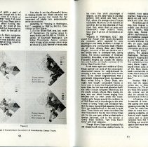
Object ID |
1987.40.01 |
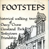
Title |
Footsteps: Historical Walking Tours |
Object Name |
Booklet |
Author |
Neighborhood Planning Councils 2 and 3 |
Published Date |
1976 |
Description |
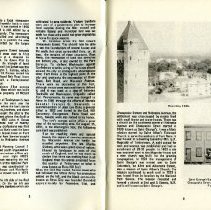
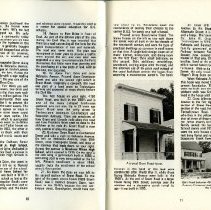
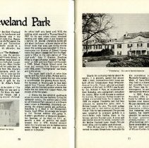
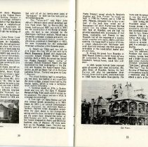
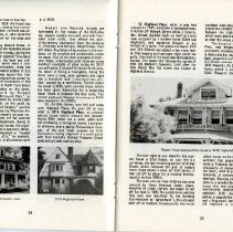
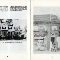
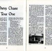
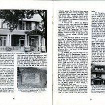
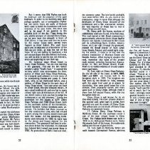
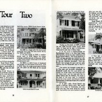
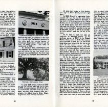
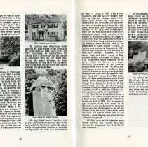
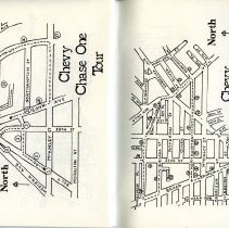
Footsteps: Historical Walking Tours of Chevy Chase, Cleveland Park, Tenleytown, Friendship Neighborhood Planning Councils 2 and 3 Cover art by Greg Pope Cover lettering by Mrs. Ann Pope Maps Photos of: 5615 Belt Road ("reportedly a tenant farmer's house") "Kline's Bakery was located here at 3915 Northampton St from 1910-1917" Stone commemorating Colonel Belt, located on the northwest corner of Western Ave and Chevy Chase Circle 3734 Oliver Street Belt Manor house before it was torn down in 1907 Chevy Chase Community Center Corner of McKinley Street and Chevy Chase Parkway Chevy Chase Brank Library in DC 5500 block of Connecticut AVe 5508 and 5530 Broad Branch 5530 Broad Branch Road Northampton Street 3300 Rittenhouse St Chevy Chase Tour One Chevy Chase, D.C. is a large residential area in the upper Northwest section of Washington. The area was converted from farmland to the fully developed residential district that it is today between 1900 and 1950. The history of Chevy Chase begins with the Nacotchanke Indians. The Nacotchankes were a branch of the Piscataways, part of the Algonquin Nation. Some missionaries later anglicized the name to Nacostines or Anacostians. These Indians had a large soapstone quarry near what is now Connecticut Avenue and Albemarle Street and a communal garden at Military Road and Nebraska Avenue. Settlements were scattered from the Potomac River northward past what is now Chevy Chase Circle. In 1721, Lord Baltimore's surveyors added a great deal of land south of Baltimore to his list of landholdings. This included a large tract west of Rock Creek which would later become Washington, D.C. Four years later, Lord Baltimore granted 525 acres of this land to a Colonel Joseph Belt of Anne Arundel County. This grant was later expanded to 1000 acres. Colonel Belt cleared land, bought slaves, built a house and moved in. He named his plantation "Cheivy Chase" after a chase or hunting ground in the Cheviot Hills of Northumberland which form the border between Scotland and England. In 1388, a battle over hunting rights in the chase was fought between Lord Percy of England and Earl Douglass of Scotland. Soonafterwards the event became the subject of many ballads in Britain. Here are a few verses from one such ballad called "The Hunting of the Cheviot." God prosper long our noble King Our lives and safeties all! A woeful hunting once there did In Chevy Chase befall. Of fifteen hundred Englishmen Went home but fifty three. The rest in Cheviot Chase were slain Under the greenwood tree. In 1890 a Colonel G.A. Armes of Tenleytown had the idea of extending Connecticut Avenue from Boundary Street (now Florida Avenue) across Rock Creek, through upper Northwest and out into Montgomery County. Armes, who lacked the capital necessary for such an undertaking, interested Senators William Stewart and Francis G. Newlands of Nevada, who had money enough to carry out the plan. They formed the Chevy Chase Land Company and proceeded to buy several thousand acres of land, including that which would be needed for the extension of Connecticut Avenue. The land company planned an upperclass neighborhood which would be centered around the new avenue. The name "Chevy Chase" was taken from the Belt family estate, one of the many farms purchased by the land company. This particular piece of land was at the center of their plan and lay on both sides of the D.C. line. So the'developers chose this as;the name of the new residential area thatthey would form and Chevy Chase retained the name which it had borne since 1722. After the land company had planned out the blocks and streets and divided the land into lots, they began to sell them to individuals who would design their own houses and have them built themselves. This is how the 3700 block of Oliver Street was developed. However, in the early twenties, people began to see the profit in buying up a whole block 'of lots and developing it for sale to future residents. This is how a great deal of the building was done during the next thirty years, speeding up the process of conversion to a fully developed area. By the 1930's, the long period of intense change was over. Nearly all the lots had been built on and the trees had grown tall enough to form shady canopies over the streets. The increasing number of families living in Chevy Chase brought new schools, churches and 'stores to the area, making it a distinct, almost self contained community. Today, Chevy Chase is one of the most beautiful neighborhoods in the Washington area. Here we will try to share with you some of the 250 years of its history. 1. The tour begins at the corner of Belt Road and McKinley Street, between 39th Street and Western Avenue. Belt Road was laid out in the early 18th century on the site of an old Indian trail. It was named after Colonel Joseph Belt, who, in 1725, was granted 525 acres (later expanded to 1000) by Lord Baltimore. The road was originally part of the Brookeville Road, which still continues north of Western Avenue. It ran from Tenleytown to Colonel Belt's plantation and out into the country towards Brookeville, Maryland. 2. Follow Belt Road north. In some places you can see where the old cobblestones have been covered with tar. On your right, you will come to a small, yellow stucco house numbered 5615. This is one of the very few houses that actually faces on Belt Road. It was built in 1903, and according to the owner, was originally a tenant house on a farm. 3. Continue on Belt Road to Northampton. In 1910, you could have stopped to buy rye bread at Klein's bakery, 3915 Northampton Street. As is usual in Chevy Chase, there is a' wide range of architectural styles on this street, including a white frame Victorian farmhouse and several modern brick dwellings. At the intersection of 39th Street is a "Hollywood Modern" style apartment, characterized by the small insets of glass brick. It was built in 1941 and now houses a children's used clothes store, managed by an area resident. Two more Hollywood Moderns can be found on 39th Street between Northampton and McKinley. 4. Turn left on 39th and proceed until. you reach Western Avenue. To your left you will find the Chevy Chase Baptist Church, built in 1925 on the former site of the Chevy, Chase Land Company. Before the present church was built, the congregation met at the Chevy Chase Theatre, now the Avalon. The church today houses a child care center for preschool children, an Area A Outreacho Center for senior citizens and other service organizations. 5. Go right on Western to Chevy Chaser Circle. At the corner on your left is All Saints; Episcopal Church. Organized in 1897 on Grafton Street in a one room school building, All Saints is the oldest church on the circle. It was originally named the Chevy Chase Church, and was planned for the Chevy Chase community by Senator Francis G. Newlands,: who donated the land on which it stands. It is' built of Rock Creek granite and its cornerstona contains documents placed there when, Kline's Bakery was located here at 391 the church was constructed. At one time, part of the church was in Maryland and part in Washington (it is all in Maryland now), and some of the people who were married there are not sure if they were married in the District or Maryland. In front of the church is a natural stone monument commemorating. Colonel Belt. 6. If you brave the traffic and cross Chevy Chase Circle, you will get a closer look at the fountain in the center. It was designed by Edward Donn, a friend of the Newlands family, and built in 1933. It is dedicated to Senator Newlands by his second wife for his successful struggle for irrigation in the West and for his pioneer development of Chevy Chase. In the spring and summer during the twenties, band concerts were held in the circle. Increasing automobile traffic put a stop to this. 7. Across the circle, on the Maryland' side, you will notice a large Tudor House of beige stucco with reddish brown trim and5 Northampton Street from 1910 to 1917 many casement windows of varying sizes. This. style was popular during the 1890's for mansions and hotels and was called Jacobethan. The house was built in 1893 by Senator New lands and was purchased in 1900 by William S. Corby. Newlands abandoned the house because it was too far out in the country to This stone commemorating Colonel Belt islocated on the northwest corner of WesternAvenue and Chevy Chase Circle. The electricity which ran the streetcars was shut off at midnight. After Corby bought the mansion, he added a music Hall shaped like a medieval church with a seventy rank Aeolian Duo Art organ in it. The Corby mansion, once known as Ishpiming, is now privately owned. 8. About half a block up Western Avenue on your right, you will find Blessed .Sacrament Church, with its stone and shingle bell tower. Built in 1911 as a mission of St. Ann's Church in Tenleytown, the original church was housed in a white building. Today, Blessed Sacrament serves a large parish and operates a nursery school, grammar school and teen center. 9. From the circle, take the first street southeast of Western Avenue leading off the circle. This is Chevy Chase Parkway, originally called 37th Street, renamed in 1925. On your left you will see a white building, the Chevy Chase Apartments. They were built in 1910 and are now owned by the Blessed Sacrament Church. Next to them, is the Blessed Sacrament School. 10. Follow the sidewalk between the playground and the Presbyterian Church to the alley behind it. A long time resident remembers shooting ducks when a creek used to run where the alley is now. Turn right and follow the alley to Oliver Street. The block of Oliver Street on which you are standing has some of the oldest houses in Chevy Chase, D.C. Oliver Street was once used as a turnaround for buses until 1942, when a small child was killed by a bus at the intersection of Oliver Street and Connecticut Avenue. The bus terminal at Connecticut Avenue was built seven years later and Oliver Street was closed to westbound traffic. This fact contributes to the peaceful atmosphere. Children by the score play street games and ride bikes and the houses are large and welcoming. The street, like so many others in Chevy Chase, is canopied by tall shady trees. 11. The low Tudor house with a large porcli and stone pillars at 3777 Oliver Street was built in 1908. It has seven bedrooms and a large front room with wooden beams, which have not been altered since the house wasbuilt. 12. The green stucco house at 3749 is one of the original Chevy Chase homes. It was built in 1908 by Dr. Egbert A. Clark and Dr. Clark's son, E. Kent Clark, grew up in the house and remembers that his "Dad was the one who walked all over the area getting families to agree to take milk from the old. +Chestnut Farms Dairy (then located on the 1100 block of Connecticut Avenue) so they would deliver out that far." "In those days," he recalls, "Chevy Chase was a long way out of the city, but Washingtonians would make the trip out in the summertime, not only for the coolness, but also to enjoy the smell of the honeysuckle on the banks of Connecticut Avenue." 13. A white frame house with a low front roof and dormers is located at 3734 Oliver Street, which is the site of the old Belt Home. The original house was built around 1725. It was a very plain, rectangular brick building, two stories high; not at all what one. would expect for the manor house of a large plantation. The Belt Manor house stood through the French and Indian War, the Revolution, the War of 1812, and the Civil War. The members of the Belt family who lived in 'the house fought in these wars. Colonel Belt himself fought in the French and Indian War and during the War of 1812. This is the house built by Brainard W. Parker at 3734 Oliver Street in 1907 on the former site of the Belt Manor house. Its foundations and chimneys were built with brick from the walls of the Belt house. Before its demolition, the house was in sight of the E.V. Brown School, the only other building in the area at the time. Miss Ella Given, a long time teacher and organizer of the school, wrote "The Belt home was torn down, and the cow, which we of the scli'nol had come to regard as a landmark, disappeared from the adjoining field. In fact, the field too soon vanished, and in its place we had a brand new thoroughfare called Northampton Street." In 1907; the lot on which the old house stood was purchased from the Chevy Chase Land Company by a young Washington. lawyer named Brainard W. Parker. Mr. Parker made plans for a much larger frame house of his own. So the old house was torn down. Parker soon had his new Oliver Street residence constructed and moved in within the year. But it seems that B.W. Parker was both the destroyer and the preserver of the aged landmark. In order to cut building costs (and perhaps partially out of compassion) Parker had the bricks from the walls of Colonel Belt's used to build the foundation and both chimneys of his own home. The brick was said to be equal if not superior to the available brick of the day. These bricks, the only visible remnant of'colonial Chevy Chase, can be seen from the sidewalk in front of 3734 Oliver. It has been said that the bricks for the manor house were carried from England as ships' ballast. The small front porch and its steps rest on a foundation of the 250 year old brick, as does the rest of the house. If you are willing to backtrack a bit and venture down the alley behind the house, you will be able to see the two old chimneys, which are beginning to look their age. 14. Continue down Oliver Street to Chevy Chase Parkway. You are now standing in the gravyard. This was the Belt family cemetery called "God's Acre." It covered the territory which now encompasses the intersection of Oliver and Chevy Chase Parkway, the triangular park adjacent to it and many of the surrounding houses and yards. E. Kent Clark, who, as we mentioned before, was a resident of Oliver Street in the early days of Chevy Chase wrote, "Just past where we lived on Oliver Street, the land dropped steeply. It was a good sledding hill, and one had to make a sharp right turn at the bottom of the hill. If you didn't make a turn you had to dodge the tombstones in an old cemetery." During the excavation for the houses at 5724 Chavy Chase Parkway and 3700 Oliver Street, both on the southwest corner of the intersection, around fourteen human skeletons were uncovered. The builders had them removed so that the construction crew, who had refused to work among the remains, would return and build the houses. All the remaining tombstones were removed by 1925 to make way for the streets and houses planned for the intersection. The graveyard had been in existence since before the revolution. It is believed that Colonel Belt himself was buried there in 1786. As generations of Belts lived and died,the cemetery grew. The last burials probably took place before 1885. As you stand at this Intersection, Keep in mina that altnougn the developers of Chevy Chase removed all the tombstones and a few unexpected remains, the vast majority of those laid to rest in Chevy Chase are still there. 15. Along with the bones, sections of cobblestone road were found, three feet deep. This road started at Belt Road, intersecting it approximately where the Chevy Chase Baptist Church now stands. It led past the Belt house and its outbuildings (barn, kitchen, tobacco house, etc.), ran right through the graveyard, crossed the Broad Branch of Rock Creek (now Nevada Avenue) and veered right, entering the woods. It came to an end near the present intersection of Morrison Street and Nevada Avenue. When trying to visualize the road, remember that none of the preseni roads existed, including Connecticut Avenue, except for Belt and Broad. Branch Roads.. There is no visible evidence of the old cobblestone road today. 16. Turn right on Chevy Chase Parkway. On the left side of the street, at 5611, 5609, 5607 and 5605 are houses built in the bungalow style in 1919. The bungalow was first built by the British in India, because, with the upper level used as an airway for circulation, they were good houses for a hot climate. Their popularity spread, and many were built in Chevy Chase, although most of them have full second floors, while the true bungalow does not. Chevy Chase is well known for its old tree lined streets. The trees provide shade in the summer and, when bare in winter, form graceful arcs over the streets of Chevy Chase. The willow oaks on this block of Chevy Chase Parkway are especially lovely. 17. Follow Chevy Chase Parkway to McKinley Street. On the southeast corner is one of the most unique houses in Chevy Chase. This Yellow Brick House was built in 1949 in the Hollywood Modern style. Notice the angular look of the house, the modernistic railing and the use of glass bricks. 18. Turn right on McKinley Street and walk towards Connectictft Avenue, admiring A "Hollywood Modern" on the corner of McKinley Street and Chevy Chase Parkway. The large brick buildings on your right are the Chevy Chase branch of the D.C. Public Library and the Chevy Chase Community Center. The E.V. Brown school was the first building on this site, built in 1898, on the land provided by the Chevy Chase Land Company. To describe the school, Edward T.. Stafford wrote in Fifty Years of Chevy Chase: "Picture an expanse of mud with a plank leading to a four room building with a pump to the right and outside toilets, while in the rear were dense thickets." E.V. Brown's first teacher, Miss Ella Given, who was also provided by the Chevy Chase Land Company, wrote, "such was the place where I had elected to teach, for I had asked for the assign, ment. I strongly suspect...that my request was granted because no one else wanted to teach in such a lonely spot...but with me it was a case of love at first sight-a choice which .1 was never to regret." The Chevy Chase Community Center 5500 block, Connecticut Avenue. The Chevy Chase Branch Library. Miss Given's love was well returned by the school's first 25 students, who came from as far as Kensington and Glen Echo,. Maryland, and by the community. She saw the school through its beginnings, through its temporary closing in the winter of 1928 which resulted from severe snow storms and high snow drifts, and through its overcrowding, which led to the building of portables near the school. When Lafayette School was built in 1931, E.V. Brown was relieved of some of its students, but continued for many years afterwards. After the school's closing, the building was used during World War II by the D.C. Office of Price Administration and in 1948 the Chevy Chase Community Center opened there. In 1952, the Chevy Chase library moved into the south wing of the Community Center from its location at 3815 Livingston Street. It became obvious that the building was rapidly deteriorating. Plans were made for a new community center and library. After much complication and lobbying by area residents, the library and community center were finally built, in 1968 and 1971, respectively. 19. Connecticut Avenue is the commercial center of Chevy Chase. In the early days, there were no stores in the area. It looked very different then. Until 1910, the street lights were gas instead of tungsten electric, and until 1940, a streetcar line ran up the avenue from downtown. Known as the' Washington Rock Creek and built in 1890 bythe Chevy Chase Land Company to attract Washingtonians "out to the country" to buy land, it ran two cars daily to Chevy Chase. It transported ice, mail and groceries as well as passengers. A mother could order cough medicine from a,downtown drugstore and the, train would carry the medicine in one of the cars to what is now the bus terminal, just below Chevy Chase Circle, and leave it in a box maintained for 'This purpose for the mother to pick up. The trolley also provided amusement; neighborhood children enjoyed smearing Ivory soap on the tracks at the turnaround and watching soap bubbles appear when the streetcar went over the rails. The. line ran past Chevy Chase to the Chevy Chase Lake, which was a favorite place of recreation for Chevy Chasers. Mr. Primm, a resident of the area for some 50 years, remembers: "Yes, the big green cars went out to Chevy Chase Lake, which was quite an amusement resort. They had some boats on the lake, a pavillion for dancing, band concerts...it was quite a nice place, and quite a nice ride..." The dam of the lake broke in the late 20's and the land company had to fill it in. The streetcar tracks were torn up in 1940, and interestingly enough, were sold to the Japanese in 1941 who were building up their armaments for the coming war. Before 1911, there were no local businesses available to the rapidly growing population of Chevy Chase other than the'few in Tenleytown, which was approximately three miles away, a considerable distance in the pre automobile era. Businessmen saw Chevy Chase as an excellent location for commercial development, but the Chevy Chase Land Company had intended Chevy Chase to be a strictly residential neighborhood. The newly formed Chevy Chase Citizens Association joined forces with the land company to prevent the developers' plans; however, the businessmen eventually won out. The first, businesses to appear on Connecticut Avenue were the Chevy Chase Pharmacy owned by Doc Armstrong and Willard Folmer's grocery store which also served as the local Post Office for several years. These stores were on the present site of Winslow Paint Store. During the ensuing nine years six new businesses opened. They were concentrated on the lower portion of the 5600 block of Connecticut Avenue near McKinley Street. Located where the Chevy Chase Lounge and Chevy Chase Novelty Shop are, were barber, cobbler and tailor shops and a grocery store. Folmer relocated his grocery to the present site of Magruder's while Lewis Waxberg opeoed a tailor shop where the Washington Federal Savings and Loan Association is situated. Unlike the stores that later operated on Connecticut Avenue, these businesses catered to the basic needs of the Chevy Chase pop-ulation. In the 1920's the business district expanded to most of its present size. Previously, all businesses had been located on the 5600 block of Connecticut Avenue. By 1927, the 5500 block which stretches from McKinley to Livingston contained twenty six businesses in-cluding the first shopping mall in the community, the Chevy Chase Arcade. The east side of Connecticut Avenue, with the exception of the old E.V. Brown School, remained undeveloped because of zoning legislation and the actions of the Chevy Chase Citizen's Association. In 1958 the National Bank of Washington asked permission to build a branch on Connecticut Avenue. The citizens saw nothing objectionable to the proposal, so permission was granted. However, Esso and Safeway had attempted several times to build on the east side and used the building of the bank as a precedent in court to receive permission to build. Esso and Safeway won the decision and. built the existing facilities. In '1973 a shopping center was built next to the Esso Station occupying the last vacant lot in the Connecticut Avenue business district. When Chevy Chase was growing up near Connecticut Avenue and Chevy Chase Circle, the area encompassed by this second Chevy Chase tour was covered mostly by farmland. As the population of Chevy Chase grew, however, it became necessary to expand, and houses began to be built towards Rock Creek Park. For this reason, most of the homes you will see on this tour were built later than those on the first Chevy Chase tour, with just a few exceptions. 1. The tour begins at the intersection of Military and Broad Branch roads. Broad Branch Road is one of the oldest established roads in the Chevy Chase area, dating back to at least 1855. It was named for the Broad Branch of Rock Creek, a stream which ran along the same route that the road follows. It is believed that there was an Indian settlement at this location; the proximity of the Broad Branch made this area a comfortable place to live and farm. 2. The houses to your left are among the most recently built on Broad Branch Road. The land on which they are built belonged to the Francis Shoemaker family, descendants of Isaac Pierce, of Pierce Mill, and was not sold and subdivided until the 1940's. 3. Continue along Broad Branch to Livingston Street. On the northwest corner of the intersection is one of the most distinctive homes in the area. This large, modernistic white house was completed in 1974 and occupies a part of a large plot of wooded land that neighborhood children long played in. 4. Along the next few blocks are the earliest houses built on Broad Branch Road. Note the imposing dark stucco house at 5503. It was built in 1914, but its oval windows are reminiscent of the Victorian age. Two McKinley stucco, 5508 Broad Branch Road. At 5508 is a house with the stucco and pyramidic point roof that was popular during the 1900's and 1910's. In the next block, at 5524, is another stucco, built in 1915. Notice the lattice windows, another earmark of this style. 5528, a green frame house constructed in 1916, has the same point roof. At 5530 is a white house of clapboard and shingle. It is the oldest on the block, built in 1913. Note the single paned glass windows and the porch on the front at the second floor. 5530 Broad Branch Road. Victorian Street house, Broad Branch Road. Further up the street, at 5604 and 5606 are two 1900 Victorian street houses. While many of these can be seen in Tenleytown, these are the only two in Chevy Chase. 5. At the corner of Broad Branch and Northampton Street is the Bon Food Store, affectionately known to area residents as the Broad Branch Market. The house was built in 1919 and was operated as a market by a Mr. Sauer until 1926, when the property was sold to Ida and Abraham Bondareff. Their son, Daniel, now manages the store and two other markets that the Bondareffs own in the D.C. area. The market has changed a great deal in its fifty years and has slowly expanded: Ida Bondareff recalls that the room which now houses the frozen foods and juices was once the living room, and the area with the ice cream freezer was the kitchen. The room in the back of the store used for household goods was once a porch; another porch facing Northampton Street was closed off to become the meat icebox. In its early years, Broad Branch was mainly a delivery service store: few people came in to shop for themselves, and even when they did, they were served by market staff. And while some area residents enjoyedwhat was then the novelty of..self service at the Safeway and Piggly Wiggly grocery stores, the Broad Branch delivery service, which is still continued today, was helpful to older residents and shoppers who had no transportation. Broad Branch Market is one of the few neighborhood markets left in Northwest Washington. It is a place where people not only buy groceries, but where neighbors meet and talk in the friendly, personal atmosphere created by the Bondareffs and their employees. 6. Turn right on Northampton Street. Just past Lafayette school, on your left, is 3307 Northampton, built in 1916 in the Hudson River style. Note the drastic slant of the roof, the squat pillars and the use of both clapboard and shingle on the side of the house. Hudson bay style house. 7. Keep walking down Northampton Street. The block between 33rd Street and 32nd Street displays the great variety of architectural styles that can be found in Chevy Chase. After World War I, people were seeking different, interesting styles in which to build their houses; the Spanish Mission style, stucco with arched doorways and often with red pan tile roofs was popular, and can be seen here at 3227. At 3224 is an impressive stucco house with a comfortably large porch and delicate lattice work windows. It was built in 1915. Notice its neighbor, at 3220. This handsome dark blue clapboard house was built in 1917. McKinely stucco, 3224 Northampton Street. Across the street and down the block a little further is a brown shingle mock chalet at 3215. It was constructed in 1916 and also has the popular lattice windows. At 3212 is a brown shingle bungalow, a popular post war style. This one was built in 1919. 8. Continue down Northampton to 32nd Street. At the southeast corner at 5622 32nd St. is a large, yellow shingle style house. It was built in 1919 to be a summer home for a resident of the "Federal City," and is constructed of shingle with a stone foundation and stone porch pillars. 9. Continue down Northampton Street. To your 'left, at 3121, 3125, 3129, 3117, 3113, and 3109 are several more houses built of stucco with a bit of Spanish influence.3121 Plateresque designs on Northampton Street. Note the hip roofs, the pillasters on the front of 3129 and 3125, the palladian windows on the sides and the varying degrees of plateresque designs on the sides and near the tops of these houses. They were all constructed in 1926. 10. Continue down Northampton and cross Nebraska Avenue. Walking up this block you will notice that you have moved into a relatively new neighborhood; the street trees are younger and the houses are constructed of brick. Giant oak, Northampton Street. 11. Cross Utah Avenue. In front of 2837 you will find a giant white oak, and in front of 2829, its larger neighbor. A U.S. Park Service horticulturist estimates their age at between two and three hundred years old-certainly the oldest trees in Chevy Chase. Imagine how much life they have seen! 12. Walk back down to Utah Avenue, turn right to Oliver Street, and turn right again. At 3060 Oliver is a gray stucco house, covered with ivy, that can be easily distinguished as the oldest house on the block. It was built in 1916 and was owned by Charles Murray, one of two brothers who immigrated to the United States; built their homes here and made their living in the city as auto mechanics. If you stand back, towards the far side of the.street, you will be able to see a delightful little widow's walk on the top of the house. 13. Go back to Utah, turn right and continue to Nebraska Avenue. On the southeast corner, at 5827, is the Edward Murray House, built in 1910. The house is partly obscured by trees, but you can see the bright blue steps, large porch and the red tile roof with the weather vane on top. The Murray brothers owned this land, from Nebraska and McKinley and from Utah to Oregon Avenue for years and then passed it on to their children. The land was sold and subdivided in the late 1940's when the brick houses of this neighborhood were built. 14. On the northeast corner stand the large red brick buildings of the Episcopal Home for Children. The Home was originally founded in Colonial Beach, Virginia, by a group of church women who set up a program for undernourished and convalescent children. In 1908, the Home moved to Anacostia in the District, and in 1930 moved to its present site. The home was previously an orphanage but is now a boarding school for emotionally disturbed boys. Three buildings, a swimming pool and a playing field cover its nine acres. 15. Walk down Utah Avenue to Quesada Street. Turn left and walk down Quesada until you reach a fork in the road. Bear right. This narrow alley like street is all that remains of Rock Creek Ford Road, which dates back to the 19th century. Rock Creek Ford Road ran from Broad Branch Road to the park and was originally known as Swart Road, for Colonel Barnett T. Swart, a farmer who owned two hundred acres of land in this area. Swart lived here for some time before1870 to about 1890, and worked for the District government from 1878 1879 as Superintendent of County Roads. Rock Creek Ford Road was also sometimes known as Milkhouse Ford Road, named for a dairy that was located near the park. The only house that now faces Rock Creek Ford Road is at 3131; it is a Pepco company house. 16. Continue up Rock Creek Ford Road to 32nd Street. Also located in this area, from Patterson to Rittenhouse and from Utah to 32nd, was a settlement of black families. They were probably employed as labprers on the nearby farms, at the mills in Rock Creek Park and by stonecutters and blacksmiths in the area. Their houses, built around 1880, were one story frame dwellings with flat tin roofs, not much more accommodating than shacks. They raised their own food in gardens and in numerous chicken sheds. The settlement lasted, surprisingly, until 1942, when it was razed to make way for the brick houses presently located here. Episcopal Home for Children. 17. Turn right to Rittenhouse Street. On the southwest corner of Rittenhouse and 32nd is the former site of the Purple Iris Inn. The Inn, which was torn down in the late 1950's to build the brick houses now occupying the lots, was a brown shingle bungalow with a large screened porch built in 1921 by the Inn's proprietor, Berthold Kolle.The Inn operated until as late as 1950, but was closed for a brief period between 1930 and 1931. Some say that the Purple Iris was an outlet for bootleg liquor during Prohibition and held speakeasy dances, which might account for its closing; before this time, however, residents remember it as a "family place." Mrs. Whitaker, a resident of Chevy Chase since 1926, recalls that the Purple Iris was "lovely, fixed very nicely," a place where "people used to ride their horses up apd go in for tea." Edgewood. 18. Walk up Rittenhouse to 33rd Street. On the corner here to your right is a pillar which once marked the entrance to the Edgewood Estate. At 6115.33rd, just a little way down the street, the estate, house still stands. Edgewood was built in 1907 by George Rees, a lawyer. He contracted the Pinehurst Park Company, who built the first homes near Pinehurst Circle, to construct a large frame house with a stone foundation and the modern luxuries of electricity and steam heating. Rees sold the house in 1909 to the Washburn family who added a stable and the post already mentioned. The house was occupied from the mid 1920's to the late 1930's by Sterling Vernon Mead, a distinguished dental surgeon and professor of Oral Diagnosis and Oral Surgery at Georgetown University. The bulk of the estate was subdivided and sold in 1937. The large white stucco house is set back comfortably from the street and faces Rittenhouse Street, as it did before the houses around it were built. The spacious front porch and arched doorway portray an atmosphere of old Southern leisure and comfort. 3300 Rittenhouse Street. 19. Continue down Rittenhouse Street admiring the older homes on the left side of the street. 3300 and 3306, built in 1917 and 1918, respectively, are constructed in the colonial style of architecture that was popular in Washington after the first World War. Notice the many windows, the stone chimneys and the large yards that distinguish these houses from the post World War II brick colonials that surround them. Gate pillar of Corbin Estate. 20. Near Broad Branch Road, turn into an alley off Rittenhouse to your right. In the backyard of the first house on the right stands a large stone gate pillar. Inscribed on the pillar is "Highwood," the name of a mansion builtby Henry C. Corbin in 1907. It had a stone foundation and was built of wooden frame with two wide bay windows facing Rittenhouse Street. Behind the house were the riding stables, and surrounding the estate were ten acres of wooded land enclosed by a high hedge. Henry and Edith Patten Corbin were members of the social elite in Washington. Edith and her four sisters were prominent in Washington society from the turn of the century to their deaths; Henry, who began his career in the Civil War, was a Major General in the United States Army and was accompanying President James Garfield when he was assassinated in Union Station in 1881. The Corbins were married on November 6, 1901, and among the guests at their wedding was President Theodore Roosevelt. In 1909 Corbin died, and Edith moved to Massachusetts Avenue to live with her sisters. The U.S. Government leased Highwood in the early 1920's for General John Joseph Pershing, Commander of the American Expeditionary Force in the First World War. Pershing was a member of the Chevy Chase Citizen's Association during his stay at High wood and was often seen by neighbors horseback riding with his son down 33rd Street. Later, the Japanese Ambassador to the United States, Tsueno Matsudaira rented the house. George Dern, progressive Governor of Utah and Secretary of War during Franklin D. Roosevelt's first administration, lived at High wood from 1932 to 1936. By 1938 the mansion was razed, and the land subdivided. 21. Turn left on Broad Branch Road to Quesada. Turn left on Quesada. About a half a block up the street at 3326 is a white frame farmhouse, built in 1859. You can suspect its age, compared to the other houses on the block, by the size and design of the house and the unusual way it is situated on the lot, not directly facing the street. Horace Jones owned the house and farmed several acres of land around it, some of which was sold to become Lafayette playground. 22. Walk down to the Lafayette tennis courts and turn right into the alley. Walk through the playground and climb the hill near the swings. On the land behind the Jones farm, near Broad Branch and Oliver, was another black settlement comprised of several small houses owned by laborers. These people were probably hired for work on farms such as Jones' and a few older residents recall hiring domestic workers from this settlement. In the direction of the basketball courts there stands .a small storage shack, the foundation of which is the remains of the foundation of one of these houses, which were razed to make way for the Lafayette School and playground. Jones farmhouse, 3326 Quesada Street. 23. Down the hill is the Lafayette Elementary School, completed in 1931. Before Lafayette was opened, area children attended the then overcrowded E.V. Brown School on Connecticut Avenue. Lafayette also serves the community as an air raid shelter and polling place, and is presently undergoing extensive modernization. |