
Object Record
Images
Metadata
Object ID |
2009.1007.01 |
Object Name |
Map |
Date |
1929 |
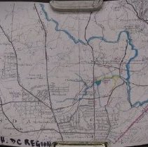
Description |
Street and topographical map of Northwest DC and Montgomery County, MD Shows road crossing Coquelin Run Rock Creek, Chevy Chase Lake, and a tributary highlighted in blue ink Proposed roadway in area of Coquelin highlighted in yellow ink DC - Maryland border highlighted in red ink Northern boundary: Alta Vista; Capitol View Southern boundary: River Road; Oxford Street; DC - Maryland boundary Western boundary: Bulls Run; English Village Eastern boundary: Woodside Cartographer: USGS Date: 1929 Size: 17" by 11" ONE EXTRA COPY MOVED OFFSITE |