
Object Record
Images
Metadata
Object ID |
2005.24.01 |
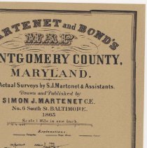
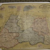
Object Name |
Map |
Date |
1865 |
Description |
Map of Montgomery County, Maryland Martenet and Bond's Reproduction drawn and published by Simon J. Martenet, CE, No. 6 South Street, Baltimore Date: 1865 Cartographer: Simon J. Martenet Northern boundary: Roxbury Mills Southern boundary: Arlington, VA Western boundary: Mt. Ephraim Eastern boundary: George Humes property Insets of towns shown: Hyattstown Poolesville Clarksburg Brookeville Plan of Rockville Barnesville Darnestown Districts outlines in different colors: Medley Clarksburg Cracklin Berry District of Columbia Rockville Scale: 1" equals 1 Mile Size: 27.5" by 35" |