
Object Record
Images
Metadata
Object ID |
2009.1003.01 |
Object Name |
Map |
Date |
1978 |
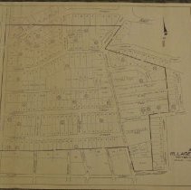
Description |
Town Map Section 5 Village of Chevy Chase Montgomery County, Maryland Plat town map of Chevy Chase - Liber and folio of each lot Features numbered plots Northern boundary: Leland Street Southern boundary: Taylor Street Western boundary: Connecticut Avenue Eastern boundary: Chestnut Street; North Central Avenue Other streets and features displayes includeThornapple Street, Underwood Street, Virgilia Street, Woodbine Street, Aspen Street, Glendale Road, Williams Lane, Brookville Road (Formerly Brookeville and Tennallytown Road) Parcel Recording Reference Tabulation Table Inset of surrounding area of Northwest DC and Montgomery County Scale: 1" equals 100' Size: 24" by 36" |