
Object Record
Images
Metadata
Object ID |
2009.1006.01 |
Object Name |
Map |
Date |
1928 |
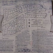
Description |
Sheet 1 of 3 Sheets comprising Chevy Chase Section 5-A Montgomery County, Maryland Plat and street map, Maryland National Capital Park and Planning Commission Cartographer: David J. Howell Western boundary: Connecticut Avenue Eastern boundary: Brookville Road Southern boundary: Woodbine Street Northern boundary: Blackthorn Street Other streets and features displayed include Glendale Road, Leland Court, shows roadway and parcel dimensions; individual numbered plots Date: August 1928 Scale: 1" equals 100' Size: 18" by 18" Owner's dedication: This declaration of dedication made this fifteenth day of October in the year nineteen hundred and twenty-eight. Witnesseth: That the Chevy Chase Land Company of Montogmery County Maryland and Edward H. Jones of Montgomery County Maryland being the separate and distinct owners of the three parcels of land comprising this subdivision, have caused to be surveyed their respective tracts of land shown upon this plat as set forth in the engineers certification hereon and by the execution of these presents and the filing and recording of this plat do subdivide the land by joint action into lots, blocks, public alleys, public highways etc. as shown hereon, to be known as Section 5-A Chevy Chase and do dedicate the said public alleys and public highways for public use for any lawful purpose whatever; And do further declare and establish perpetually the building restriction lines as hereon indicated dotted, beyond which the erection of any building, porch thereof any structure of a permanent nature exceeding four (4) feet vertically is restricted..." |