
Object Record
Images
Metadata
Object ID |
2009.1002.02 |
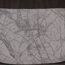
Object Name |
Map |
Date |
1915 |
Description |
Map of Bethesda District of Montgomery County, Maryland Greater area of Bethesda, Chevy Chase, upper northwest DC, and small part of Northern Virginia Street and land tract map Northern boundary: Snake Den Road; Forest Glen Railyard Southern boundary: Langley, Virginia; Wesley Heights in DC Western boundary: Cabin John Park Eastern boundary: Takoma, MD; Brightwood in DC; Metro Branch (B&O Railroad) Cartographer: S.D. Caldwell Other streets and features displayed include Bradley Lane, Rockville Pike, Chevy Chase, Washington and Great Falls Railroad, Glen Echo Railyard, Massachussetts Avenue NW, American University, Boundary of District of Columbia and Maryland, Rock Creek Park, 14th Street Road NW, Cleveland Park, Pierce Mill Road NW, Louhboro Road Date: 1915 Scale: 2" equals 1 mile Size: 17" by 11" ONE EXTRA COPY MOVED OFFSITE |