
Object Record
Images
Metadata
Object ID |
2009.1002.03 |
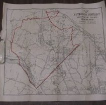
Object Name |
Map |
Date |
Circa 1915 |
Description |
Map of Bethesda District of Montgomery County, Maryland Greater area of Bethesda, Chevy Chase, upper northwest DC, and small part of Northern Virginia Street and land tract map Northern boundary: Snake Den Road; Forest Glen Railyard Southern boundary: Langley, Virginia; Wesley Heights in DC Western boundary: Cabin John Park Eastern boundary: Takoma, MD; Brightwood in DC; Metro Branch (B&O Railroad) Cartographer: S.D. Caldwell Red ink outline in Montgomery County from DC - Maryland boundary (Western Avenue) on the south; Orndorff Mill Road and Bangarter Road to the north; Cabin John Run on the west; and Rock Creek on the east Other streets and features displayed include Rockville District 4, Orndorff Mill Road, Wheaton District, Seven Locks Road, Wetzell Road, Cedar Lane, Rockville Pike, Connecticut Avenue extended and 16th Street NW, Brookville Road, National Park Seminary, 16th Street extended and 16th Street NW, Silver Spring, Daniels Road, Bradley Lane, River Road, Jones Mill Road, Otterbourne Date: 1915 Scale: 2" equals 1 mile Size: 17" by 11" ONE EXTRA COPY MOVED OFFSITE |